Welcome to ""Jacksonville on Foot"

Jacksonville is the largest city in the State of Florida and the city with the largest geographical area in the contiguous United States. Jacksonville has a rich history enhanced by it's proximity to the St. Johns River and the Atlantic Ocean with weather that makes it easy for people to explore the city on foot whether it is a more remote wilderness hike or a leisurely stroll in the downtown core. Visit "Jacksonville on Foot" often to get ideas for your next adventure.

Friday, December 2, 2011

Walk 10,000 Steps A Day

Many health and fitness experts recommended that people walk 10,000 steps a day for minimum fitness. That is roughly equivalent to walking five miles a day.

Several years ago, when I first learned about walking 10,000 steps each day, I had no way of quantifying my movement. So, I started wearing a pedometer as I went about my daily activities. I was working a job that often required me to be on my feet for 10-12 hours, so those steps added up really fast on the days I worked. My days off had usually been more sedentary, so I intentionally made sure I met the 10,000 step minimum on those days too. 

During the busy Christmas season I was averaging 15,000 steps a day. An amazing thing happened. I was able to enjoy eating delectable goodies throughout the holiday season at the private club where I worked without gaining a pound! Other people would bemoan the fact that their waistbands were feeling snug, but I sailed through the holiday season as if it never happened.

An interesting thing occurs when you make an effort to consciously move your body. You soon get used to it and begin to miss being active. It is at that point when it is easiest for you to be able to commit to continuing toward a more healthy lifestyle that can add quality years to your life.

I have followed the 10,000 steps a day concept for years now, and I am easily able to maintain an ideal weight without constant dieting. Although I am careful about my overall daily nutrition, I do not feel guilty when I eat an abundant meal at a special occasion. If necessary, I will walk extra steps to allow myself to enjoy meals without counting calories.

Rather than wait until the beginning of the year to make a New Year's Resolution to take off those extra pounts, I challenge you to do something to keep from adding extra weight to begin with. Take some time to get out & about to see a bit of Jacksonville on foot!


Along the trail at Betz-Tiger Point Preserve


Happy Walking!


Wednesday, November 30, 2011

Fort George Island Cultural State Park Multi-Use Trail


Fort George Island Map

During the eight months I have lived in Jacksonville, I have never heard anyone speak of Fort George Island as a destination spot. Probably, most of them opt for a day at Little Talbot Island State Park three miles up the road.

Fort George, a gateway to the Timucuan Preserve, is part of the Florida State Park system and offers several options for outdoor activities. Of course, my husband and I came looking for a place to walk/hike. We found an awesome 3-mile multi-use trail that is shared by hikers & off-road bicyclists. It follows the interior of the former golf course that is a remnant of a by-gone era when Fort George Island was frequented by the rich & famous.

Amazingly, while researching the park, I learned the island features Mount Cornelia reported to be the highest point along the Atlantic Coast south of North Carolina's Outer Banks. We were definitely able to reach a high spot on our hike that is uncommon to Florida.

The park is located at 12157 Heckscher Drive in Jacksonville, (904) 251-2320. It is open from 8:00am to sunset 365 days a year. There was no fee to enter the park, but the brochure we picked up during our visit indicates a fee and/or additional fees may be required. If in doubt, call ahead. The Ribault Club, featuring exhibits related to the island's history, is open Wednesday-Sunday 9:00am-5:00pm and is closed on Thanksgiving and Christmas Day. The club's facilities can be rented for special occasions such as wedding receptions. The loop trail begins and ends across the road from the Ribault Club (pick up a trail map there) close to the parking area.

The Kingsley Plantation, another historic point of interest, is part of the park. It is on our list to visit another day.


Ribault Club

Distance:
  • 3 miles +
Terrain:
  • Maritime forest with sandy soil featuring a cross slope exceeding 5% at one point plus a grade exceeding 12% at Mount Cornelia. 
Amenities:
  • There is ample parking at the Ribault Club along with restrooms and a shaded picnic area. There is also a boat launch on the back side of the club suitable for canoes, kayaks and small flat bottom boats. Bicycling is possible with big tires on the multi-use trail. Another biking/walking option is possible along the park's paved and gravel roadways.
Pets:
  • Well-behaved pets are allowed on a leash not exceeding 6 feet in length. Bag waste as a courtesy to other users of the trail.
Wheelchairs:
  • Not recommended, but the grounds surrounding the Ribault Club are a suitable option along with other scenic areas within the park.
Modifications:
  • The hike exceeds 3 miles a bit by opting to take the side trip to Point Isabel, which is well worth the view of the water. There are two trail options when you reach Mount Cornelia, but most people would simply view the steeper route as a higher than normal rise along the trail. It might be difficult for someone with limited lung capacity or another significant physical problem but not for a reasonably well-conditioned individual. Some people choose to opt out of doing the complete loop and just hike to Mount Cornelia or Point Isabel and back to the parking area.

The Hike

We proceeded to the trailhead from the parking area by walking across a field somewhat parallel to the roadway we arrived on to reach the Ribault Club. This approach sent us traveling along the trail in a clockwise direction. 

The park gets a "thumbs up" for having a well-marked trail that is easy to navigate. This is important to us because my husband and I have found ourselves in areas where we did not have a clue where to go next...the blazes or other trail markings just "disappeared" or were non-existent. Badly marked trails are not only annoying...they can be dangerous.


Trail Markings

The sandy soil is typical for many trails in and around Jacksonville, so it is important to wear appropriate shoes that are comfortable with adequate support and traction for this type of trail. My husband wore low-cut hiking shoes, and I found my running shoes to be suitable.

The map we picked up at the Ribault Club was so well-marked we knew where to expect an elevation gain, when we were about to encounter an exceptionally soft surface or 3-inch tree roots. Part of the attention to detail is probably to help bicyclists safely navigate the trail, but it benefits people traveling on foot too.
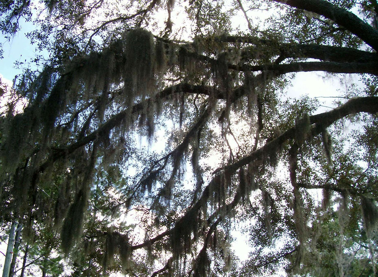

Maritime Forest

Most of the trail is under a canopy of trees, but it is interspersed with open areas that were once the fairways of the golf course.


Tree of Autumn

Fall Leaves & Spanish Moss

The beautiful and interesting vegetation along the trail provides an important habitat for birds and other types of wildlife. We heard activity and sounds in the bushes, but the critters were keeping a low visible profile when we were moving along the trail.

We saw a huge quantity of fresh wild hog tracks while we were hiking. They seem to have a preference for the open sandy areas where it is easy for them to root around in the soil. There were wildlife trails at numerous points that also had been tracked by hogs. Hogs are not something we want to ever encounter up close. They have huge tusks and powerful bodies. Humans are no match for them.


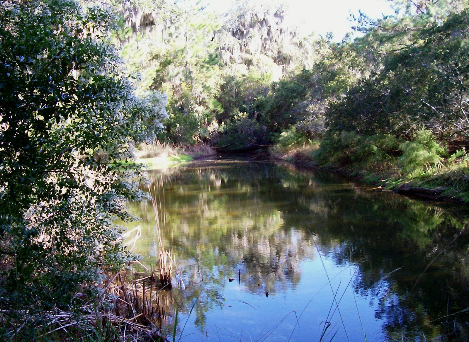
Fort George Island Pond

There is a pond on the right about midway along the hike with a spillway that is routed under the trail to the other side. At certain times, when there has been a lot of rain, I would imagine water might be flowing rapidly. We caught it on a still day, but it was picturesque anyway. We did not determine if the pond is fed by a creek.

Pond Spillway

There were informational kiosks along the trail providing details about the relationship of migrating birds to seed dispersal within the park, especially along the abandoned golf course fairways. The University of North Florida collaborates with the park to assess the effect birds have on new plant species.

Seed Dispersal

The side trip to Point Isabel offered spectacular views of the Fort George River. One high bank overlook was considerably undercut, so we were careful not to step too close to the edge in case the soil was unstable. There are stairs that go down to an area along the water fortified by a concrete bulkhead with access to a small sandy beach that is exposed at low tide. This would be a good spot for a simple picnic.

Point Isabel Sandy Beach

We did not know anything about the geographical signifigance of Mount Cornelia when we began our hike except it represents the highest point on the trail. Relative to our hiking experiences in other parts of the country we consider this to be a hill. With a 12% grade we WERE careful to watch our footing because the trail was a bit rough in places. Injuries can occur when you least expect them. Although we do like physical challenges, we definitely make an effort to stay safe. Signage along the route offers the option of eliminating Mount Cornelia from the hike and remaining on the Mail Loop instead.


Trail to Mount Cornelia

It is not very far from Mount Cornelia to the parking lot at the Ribault Club where we were able to enjoy a couple of points of interest before we left the area. The picnic tables close to where we parked are a good option for hikers who do not want to eat on the trail or anyone coming to enjoy other features of Fort George Island. There is also the opportunity to glean a bit of historical information about Spanish influence on the island centuries ago.


Ribault Club Picnic Area

Mission of San Juan del Puerto Historical Sign

Additional information about Fort George Island can be obtained via Florida State Parks at:  http://www.floridastateparks.org/fortgeorgeisland/


Happy Hiking!

Tuesday, November 22, 2011

Cedar Point Preserve Branch Trail Hike

Last week, my husband and I wanted to do an easy hike close to home as part of our recovery from a challenging backpacking trip in South Carolina along the Chattooga River. We know it is best to follow strenuous exercise with some easy to moderate activity in order to maintain a certain level of fitness as well as to relieve any soreness that might be present.

We decided a trail hike in the Cedar Point Preserve would be a good outing for what we had in mind. It is part of the City of Jacksonville Preservation Project and is located in Oceanway on Cedar Point Road close to the Pumpkin Hill Creek Preserve State Park and the city's Betz-Tiger Point Preserve.

You will turn right off Cedar Point Road into the parking area just after the brown approach sign for Pumpkin Hill Creek Preserve. Watch for Darcy Drive, the last road on the right just before arriving at Cedar Point Preserve. There may be other vehicles speeding along right on your tail, so give yourself enough time to slow down before exiting Cedar Point Road.

There is no entrance fee, and trails can be accessed from sunrise to sunset. For additional information call (904) 630-CITY (2489).


Cedar Point Preserve Trail Access

Distance:
  • 5 miles
Terrain:
  • Wide flat pathways. Some sections could have standing water following rain or be a bit mucky. There is no problem with large roots crossing over the trail and no apparent elevation gain.
Amenities:
  • Ample parking, but there are no picnic & restroom facilities or potable water. Treat this hike as a wilderness experience where you bring what you need for personal needs, and be willing to "rough it" a bit even though the walking will be easy.
Pets:
  • Leased pets are allowed. Please bring a bag for waste out of consideration for other hikers.
Wheelchairs:
  • The area does not specifically have a designation for wheelchairs, but the trail could be navigated with big wheels. It would be wise not to take a wheelchair on the trail alone in case there are areas where it would be best to be pushed along for awhile.
Modifications:
  • The Branch Trail "branches off" in many places, so it is easy to make the hike longer or shorter to suit your needs. The shorter Main Trail (2.1 miles) is another option.

Cedar Point Preserve Informational Kiosk


The Hike


BRING INSECT REPELLENT!


I will seldom "scream" at a reader using bold letters in one of my posts, but you will thank me for telling you to remember to have insect repellent ready to use. Unless it is a cold day, there will be mosquitoes and lots of them. Insect repellent can make the difference between having an enjoyable hike or a miserable one.

We took the time to study the map on the kiosk at the trailhead. It is not easy to access detailed maps for trails in the area, but what I call a "stick map" displayed at the kiosk is better than most. My husband and I are out & about so often we have invested in a GPS that definitely makes our hiking easier. At the very least, it is advisable for any hiker to pack a compass and know how to use it.

The kiosk map showed the Branch Trail to be marked with double blue blazes and the Main Trail to be marked with a single blue one. Initially, we had to walk along the Main Trail in order to access the Branch Trail.


Cedar Point Trail Blazes

We did not see as many birds & other wildlife as we do on most of our hikes, but we did spot a raccoon as we approached from a curve along the trail. I believe this may have been the first time I ever saw a raccoon really run. There was also a squirrel up a tree close by. We expected to see a lot of birds with the trail system bordering an estuary, but I only recall seeing one fluttering around in the bushes on this visit. Perhaps we will see more next time.

The Cedar Point Preserve consistently offers beautiful scenery and the opportunity to enjoy a Florida wilderness experience encompassing approximately 631 acres within the city limits. It can be appreciated for it's solitude and a place to breath fresh air.

Saw Palmetto

Of course, we saw an abundance of saw palmetto. It grows like a weed in Florida forests, but it was a very useful plant for the Timucuans (also called Timucua) who inhabited the area long before the Europeans arrived. Today, it provides a habitat for birds & animals. It is also important for erosion control.

Most of the Yellow Branch Trail is under a canopy of trees, but there are many areas where we were able to veer off the main part of the trail to view the estuary. The salt marsh ecosystem of the estuary provides an important habitat for wintering & migratory birds.


Tree Canopy

Cedar Point Preserve Estuary

Our November hike allowed us to see fall colors and a plentiful amount of Spanish moss along with other plant life.


Tree Ferns
Fall Leaves
 
Spanish Moss

Remember the mention of mosquitoes? Well, we left the house without our insect repellent. I actually forgot to pack it, but we really expected to be okay on a cool morning. The mosquitoes immediately found my husband's exposed hands as soon as we hit the trail. Fortunately, I was wearing gloves, and both of us were wearing long pants with a long sleeve shirt. This saved the day as far as completing our hike, but we ditched the idea of a picnic along the trail and opted to dine in the van after our hike.

We were lone hikers in the woods on this trip although we are aware of recent organized group hikes. During our previous stops to view the kiosk and trailhead we have not seen evidence of anyone else using the trails, which leads us to believe personal space on the trails would never be an issue.

We learn something on all our hikes, and we try not to make the same mistake twice. Now, we know NEVER to hit the trail without insect repellent in Florida.


Towering Pines


Happy Hiking!
&
Happy Thanksgiving!


Monday, November 7, 2011

Jacksonville's "Top to Bottom" Walking Tour

Fountain at Jacksonville Landing

Sometimes when you are new to a city it just makes sense to pay someone else to show you around a bit. A guided tour allows you to experience part of a city from an enhanced historical perspective, may give you a glimpse of places not generally accessible to the public and offers a bit of group camaraderie.

A couple of months ago I came across Jacksonville's "Top to Bottom" Walking Tour while surfing the web and thought I would give it a try. It turned out to be a really good way to experience some of what Jacksonville has to offer in the downtown core.

The tour is operated by Ad Lib Tours (904) 827-1845 and leaves from the base of the escalators at Jacksonville Landing (2 W. Independent Dr., Jacksonville, FL. 32202) at 10:00am each TUESDAY and concludes at 11:45am. The cost is $20/person ($15/person in summer or w/coupon).

Distance:
  • 1 to 1-1/2 miles (approximate)
Terrain:
  • Flat city streets, some stairs within buildings.
Amenities:
  • Scenic views of Jacksonville landmarks, easy access from major hotels, downtown public transit close by, restroom facilities.
Pets:
  • Contact Ad Lib Tours (904) 827-1845.
Wheelchair Access:
  • Contact Ad Lib Tours (904) 827-1845. My opinion is that most, if not all, of the tour could be enjoyed from the vantage point of a wheelchair, but it is best to check with the tour company before making that assumption. There are stairs in a couple of buildings that would be problematic.


The Walk

Meet at the base of the escalators inside The Landing. They are easy to find no matter whether you enter the building from the street side or the river side. The escalators allow access to the Food Court and other restaurants on the second level with an awesome view of the St. Johns River.

Arrive promptly by 10:00am, so the tour can start on time. Have your money ready unless payment has been made ahead of time. I am sure it would be appreciated if the guide does not have to make change. This gathering is very informal, and you will be given a quick overview of what to expect before heading out for the tour.

Dress comfortably for walking, but remember this is a business district. You might not want to dress like you are going for a day at the beach although I am not aware of any dress restrictions.  In the summer, you could benefit from a hat and sunscreen. It is advisable to carry an umbrella if there is any chance of rain. There can be quite a breeze blowing off the river, so carry a light jacket if you have a tendency to be cold-natured when the temperature drops below 80 degrees.

Expect to meet locals as well as people from out-of-town. In fact, this is a good outing for house guests who are visitng the area.

I am not outlining the walk with as much specific detail as my other walks as a courtesy to Ad Lib Tours. It is good for participants to be able to anticipate the tour with a sense of adventure and not take away from some of the unexpected things you will experience along the way.


Statue of Andrew Jackson

Jacksonville was named after Andrew Jackson. It should not be too much of a surprise to see this statue mounted in a traffic circle outside The Landing at the beginning of the tour.


Bank of America Tower

You will learn important details about some of the downtown buildings, old & new. There will be access to some "secret" areas underground with an unexpected history lesson about Jacksonville's past as a major financial center.


Underground bank vault


Another way to keep assets safe

Expect to pay a visit to the "new" library located across from Hemming Plaza at 303 N. Laura Street and be able to view the handmade tiles on the wall. Although the library is only a few years old it is architecturally more reminiscent of a previous era.


Tile wall at Jacksonville's Downtown Public Library

Other interesting information awaits as you view Hemming Plaza located in the heart of the city's government center across from the library. It was established as a public square in 1857 and was named in honor of Civil War veteran Charles C. Hemming who left an important historical legacy for Jacksonville.

Hemming Plaza

One of the high points of  the "Top to Bottom" Walking Tour includes a visit to the historic Florida Theatre where you get a bird's eye view of the downtown area. Elvis Presley's performance here early in his career created quite a stir in Jacksonville.


View from the top of the Florida Theatre

There is a chance to see eye-catching buildings anywhere along the way. The "retro" style of one of the vacant buildings that once housed the public library is quite unique.

Former Jacksonville Public Library

Impressive tile mural at former Jacksonville Public Library

It is only fitting for the tour to end back at The Landing along the banks of the beautiful St. John's River making Jacksonville aptly named "The River City".


Runners sculpture along the St. Johns River

Main Street Bridge
aka
John T. Alsop, Jr. Bridge

Contact Ad Lib Tours for additional information (904) 827-1845.
http://www.adlibtours.com/Tours.html


Happy Walking!

Thursday, October 20, 2011

New Berlin & Yellow Bluff to The Early Spot in Oceanway

Sometimes you just want to go for a walk in your own neighborhood but mix it up a bit. This is the perfect opportunity for getting up close and personal with the area where you live and have a better picture of what is really going on close by.

One afternoon a few weeks ago I decided to walk to a coffee/sandwich shop that recently opened in a strip mall a couple of miles from the house. I had been there before and wanted to go back to try something different.

The neighborhood I left behind when I moved to Jacksonville from Seattle had an awesome mix of small businesses within easy walking distance, and I always make an effort to support independent businesses as much as possible. They give our communities character. 


Spanish Moss Draped Oak Trees

My neighborhood does not have a stellar walkability score, but I try to make the best of the cards I am dealt, so I set out with my camera in hand on my way down the street.


Distance:
  • 3.25 miles (out & back)
Terrain:
  • Sidewalks & road shoulders.
Amenities:
  • Well-traveled road suitable for walking alone, convenience stops available for beverages & snacks or a full meal, chance to admire newer housing developments & interesting landscaping.
Pets:
  • Leashed according to city ordinances. Be a good neighbor and bag waste.
Wheelchairs:
  • Not a suitable means of transportation to The Early Spot, but part of the route is a good outing.
Modifications:
  • Tour housing developments with a low traffic profile off Yellow Bluff Road & Alta Road.


The Walk

  • Let's just say for the purposes of this blog that I started my walk at Walgreen's at the intersection of  New Berlin Road & Yellow Bluff Road. Actually, it was a farther distance away, but I choose not to disclose my home address on the internet. I am sure you understand.
  • I followed Yellow Bluff Road heading south toward Faye Road & 9A taking time to admire the nicely landscaped entrances to housing developments as I walked along.


Beautiful Landscaping

Stunningly Colorful Coleus

  • Eventually, I came to one of my favorite points of the walk...a bridge crossing over a beautiful estuary that is a tributary of the St. Johns River. It is possibly part of Dunn's Creek. I had been walking on the east side (left) of Yellow Bluff Road and crossed over to the west side because the sidewalk was ending. There is a pedestrian walkway over the bridge creating a safety barrier from traffic on both sides, but there is some overhanging vegetation on the east side that is a bit annoying. I did take photos looking toward the east before crossing to the west side. The views from the bridge are awesome!


Estuary on Yellow Bluff Road

  • Past the bridge, Yellow Bluff Road become Alta Drive. There is a large industrial park called NorthPoint located on Port Jacksonville Parkway that cuts through to a quite rural section of New Berlin Road. The walk can easily be extended at this point for a really long workout, but I continued along Alta Drive. The route takes on a more wooded look from here to where The Early Spot is located. There are more beautiful plants and trees.


Wooded Lot on Alta Drive


Pampas Grass

  • Pampas Grass lines the border of the yard where the sidewalk ends, but I was able to continue walking along the wide shoulder for awhile. This put me in the vicinity of Aldersgate Road. The shoulder does get more narrow before arriving at The Early Spot, so I eventually crossed to the east side to be safely facing traffic for a short distance until I got there. Traffic can be heavy here because there are on/off ramps for 9A beyond Faye Road.
  • The Early Spot is located at 2467 Faye Road. I like to have something to eat or drink at one of the cozy tables, but takeout is popular for people on their way to work or on a quick lunch break. Visit them online at:      http://www.theearlyspot.com/


The Early Spot

Chicken Pesto Sandwich with Provolone

Hip Artwork at The Early Spot

  • I finished my tasty lunch and headed back to my starting point managing to see more interesting things along the way. My eye for detail allows me to see beauty in unusual things, something I hope will be pleasant for you.


Graphic Art Courtesy of JEA

Keep the Animals Safe

Lantana

Happy Walking!

Wednesday, October 19, 2011

Huguenot Memorial Park

Huguenot Memorial Park

The Huguenot Memorial Park is one of many Preservation Parks owned by the City of Jacksonville. It sits with the Atlantic Ocean on the east side and Fort George Inlet along the interior portion. A drive to the park's location at 10980 Hecksher Drive is one of the most scenic in Jacksonville and a gateway to many outdoor activities.

My husband and I like to see what is in our own "backyard", and this park seemed like a good place for a Sunday outing close to home. We happened to visit on a rainy day, so the weather was not perfect. Also, access to the Atlantic Ocean side of the park was closed because of high tide. We still managed to get in a decent walk and make note of things we would want to see on a future visit. For us, it is always about the adventure.

There are entry fees for the park of $1 per person from 8-10 AM, $3 per car up to 6 people 10 AM to Close w/$1 for each additional person. The park is open 7 days a week. It is recommended that you call the Resident Park Manager at (904) 251-3335 for specifics related to beach closures, camping reservations, etc. The park is very busy on the weekends during the summer, so it is wise to get there early for choice parking and access to picnic areas. I have seen cars backed up to Hecksher Drive waiting to get through the gate. 
                                                                            

Distance:
  • 2.65 miles (modified out & back).  Included a short side trip to the bird observation area.
Terrain:
  • Sandy beach, paved roadway & boardwalk trail.
 Amenities:
  • Easily walkable area with beach access, parking, picnic facilities, restrooms, food concession kiosk, suitable for water sports & fishing, camping & showers, birding opportunities.
 Pets:
  • Must be leashed and not a nuisance. Bag waste.
 Wheelchairs:
  • Definitely suitable for paved areas, but accessing the beach would be dependent on the type of wheels.
Modifications:
  • Easy to modify distances in order to increase or decrease the length of the walk.


 The Walk


Our walk originated from the parking lot that is at a point on the park map south of the two arrows designating the picnic shelters. Everything at the park is out in the open, so it can't be missed. There are other parking options as you enter the park, but the one we chose is centrally located.

We walked to the Atlantic Ocean where we were at least able to view the water (beach was closed due to high tide) and stopped for photographs. A view from a camera helps give me a different perspective about what I see when visiting the outdoors. The simple things often seem more beautiful.


Atlantic Ocean Seafoam

Florida or the South Pacific?

The ocean water was very turbulent and the wind strong, so we opted for quickly moving to the Fort George Inlet side of the peninsula and headed north. At low tide, we would have been able to loop all the way around the peninsula including the Atlantic Ocean beach and return to our starting point. High tide conditions made it necessary to walk out & back along the more protected side. This was fine for a short afternoon visit, but I would definitely want to return again at low tide for a more scenic walk.


Protected Sand Dunes

Sand dunes play an important role in the ecosystem. The accumulation of wind-blown sand held in place by native plants helps to minimize erosion from wind, waves, tides & storms. The sand dunes are essential for preserving the Florida coastline and provide a habitat for nesting sea turtles and protection for waterfowl. We saw signage prohibiting access to sand dune areas.


Sand Dunes with Native Vegetation

Fort George Inlet

When we returned to the van we decided to stop at the parking lot that would be on the left BEFORE the gate when coming into the park and walked the short distance to a boardwalk that leads to an observation deck overlooking a salt marsh estuary along Fort George Inlet.

Huguenot Memorial Park is part of the Great Florida Birding Trail and provides a nesting area for terns & shorebirds. The overlook is a peaceful spot for bird watching or a moment of reflection.


Estuary Overlook

There is beauty to be found in the park no matter what the weather is like.  I would like to visit on a bright sunny day and might return to be there in a winter storm.  No lightening please!!!


Happy Walking!